Heritage & History
Geography
Clarence is 53.6 square miles with a population of 32,950 (2020). Tonawanda Creek is the northern boundary and the only natural one. Transit Road (Route 78) is the western boundary and Davison Road defines the eastern boundary (turns into Berghorn Road). The southern boundary follows Wehrle Drive from Transit, then is a political boundary to the east.
Clarence has five hamlets - The Hollow (1799), Clarence Center (1829), Harris Hill (1807), Swormsville (1830s), and Wolcotsburg (1840s), but no villages. Tonawanda Creek drains the northern part of Clarence, with Ransom Creek the largest tributary. The Onondaga Escarpment running east/west through the southern part of town is the largest elevation change and alters the elevation by 60-80 feet.
Prehistory
Clarence was occupied for thousands of years by many different Native American peoples. Their fires have long since burned out and their villages, longhouses, and wigwams have decayed away, but their stories are not forgotten. Little physical evidence remains today of these people, but their stone tools, cooking vessels, and material culture can still be found throughout the town. An occasional stone tool or projectile point may surface in a field or construction site, reminding us of these past people.
The first Native Americans to cut trails through the town were most likely the Paleo peoples who settled throughout North America after the last Ice Age. Only a few possible Paleo artifacts have been recovered in town. These people hunted large mega-fauna and knapped beautiful fluted projectile points. They were hunters and gatherers and didn’t settle in one place for too long. During the Archaic period, a large shallow lake (Lake Tonawanda) existed between the Niagara and Onondaga Escarpments, the remnants are Tonawanda Creek, the town's northern border.
With the introduction of sustainable food sources, the three sisters' corn, beans and squash, and ceramic technology, populations became more sedentary. The clay in Clarence north of the Onondaga Escarpment, the lake bottom, was used to make ceramic pots and pipes. The pots were used for cooking and food storage and the pipes were smoked to contact the spirit world.
The Early, Middle and Late Woodland periods saw more sedentary populations with larger village sites. These villages were located inland from the shores of Lake Erie and Ontario for protection from the elements and were often found along smaller creeks and streams. Village sites have been found along Ellicott Creek, Tonawanda Creek and Ransom Creek.
The historic Native tribes would have been a mix of the Erie, Neutrals (Kah-quah or Attiwondaronks) and Wenro (Wenrohronon) tribes who allied against the Haudenosaunee, but were eventually dispersed by the Seneca during the Beaver Wars. The Wenro eventually moved further north and some west. The archaeological evidence of the Late Woodland period is not well understood and further investigations are needed.
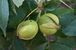
The town was referred to as Ta-Num-No-Ga-O or place of the hickory tree. According to Morgan (1852), hickory wood was used for arrow shafts, bows, and snowshoe rims. The bark was made into strips for tray and basket making and also had medicinal properties. When chewed, it helps with digestive issues and elevates sores in the mouth. The bark was also used for healing skin inflammation and wounds. The inner bark was used for making baskets, trays and canoes. The nuts were collected and eaten or ground for nut oil used in cooking.
Joseph Ellicott mentions the Tonawanda Village in his writing, probably the largest and closest village to Clarence. The Tonawanda Reservation was established in 1794 at the Big Tree Treaty, located east of Clarence. Many Haudenosaunee still live in Western New York, the closest reservation is the Tonawanda Reservation, the Tuscarora Reservation northwest and the Salamanca to the south. At one time the Buffalo Creek Reservation was to the west.
Early History
The region now known as Western New York was first claimed by the French, the first Europeans to establish a fort at Niagara in 1726. The French lost their claim in the French and Indian War and the British then laid claim to the region. After the American Revolution the Americans claimed the land and Massachusetts and New York both claimed this area. Massachusetts was in need of money after the Revolution, so they sold their claims to negotiate with the Haudenosaunee western lands in the Hartford Treaty in 1786.
The town’s namesake is from the English House of Clarence. It is not yet known why the town's founding fathers named it after the Duke of Clarence, King George III’s third son. Clarence was founded as one of the three original towns of Niagara County. Over time, other towns were formed within the original town's boundary.
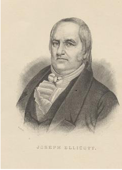
Joseph Ellicott and 150 other men braved the wilderness and surveyed the Western New York tract in 1798-1804 (Right). Like the Lewis and Clark expedition a few years later the men surveyed unknown lands, walking and living in the wilderness. Many of these men's names didn’t make the history books, but because of their hard work and dedication to the task at hand, they helped divide up the territory into reservations and townships.
In 1799, Asa Ransom took up the offer of settling in a 150-acre plot, Township 12, Range 6, Lot 12. Asa was born in Connecticut in 1765 during the beginning of the colonial upheaval with Great Britain. Asa was a silversmith, like Paul Revere, and used this skill to befriend the natives who lived in the area. This was an important skill to have as his trinkets were highly valued by local native populations. This started a peaceful relationship with said populations and allowed for a smoother acceptance of European settlement in the area.
To settle in Western New York the important things needed were first taverns to house and feed weary pioneers heading further west. Once taverns were established sawmills and gristmills were built to grind grain and cut lumber for building structures. Joseph Ellicott kept detailed notes of all the taverns and mills built throughout Western New York.
The first settlers came from New England - Massachusetts, Connecticut, Rhode Island, and Vermont. Others came from the south, mainly Pennsylvania. They started settling the Hollow (1799) the town was established one generation after the Revolutionary War and settled by veterans of the war. Over twenty Revolutionary War soldiers slowly traveled after the war heading west and established their own America. Men like Asa Harris, Jonathan Blount, and Nathaniel Gallop to mention a few.
The Town’s first meeting was held in Elias Ransoms Tavern on Main Street in present-day Williamsville, on March 11th, 1808. Twenty-two men gathered to discuss issues like roads, wolves and taxes. The first problem discussed was wolves and it was determined the town would pay $5.00 per wolf pelt. Panthers, mountain lions, rattlesnakes and bears also existed in the forests of early Clarence. The land had to be cleared and the wilderness tamed to make it livable for the early pioneers.
Industry
The earliest industry was hospitality as taverns were built to house Revolutionary War veterans, adventurers and pioneers heading west. In order to survive the harsh conditions of the early 1800s, land was cleared to farm wheat, grain, and corn, as many settlers found farming to be an essential industry. Joseph Ellicott also tasked the early settlers to erect mills near their taverns. Several saw and grist mills were built along waterways and used throughout the town. Farming remained the prominent industry in town until the mid-1900s. Farming is still an important industry in the town today.
The question was what to do with all the wood that needed to be cleared for farming? Thousands of acres need to be cleared to plant crops for food. The first sawmill in town was erected in 1804 by Asa Ransom located where the creek bearing his name falls over the Onondaga Escarpment. There was too much lumber to be cut and processed, so an early industry was making potash. Potash is the byproduct of burning hardwoods and adding salt to the ash. Potash was used for many things, from fertilizer in the fields to an ingredient in making soaps.
The clays of Ransom Creek that were once used to craft the pots and pipes of the natives were industrialized in the mid-1800s to make bricks. The Eshelman family used the quality clay, found along Ransom Creek, to build their homes and store in Clarence Center. The bricks were from the Eshelman brick yard next to Ransom Creek. They also built the large square corner storm at the corner of Goodrich and Clarence Center Road (Right). Most of the brick homes in Clarence Center were built with local clay from around Ransom Creek. There was a brick yard in Clarence Hollow as well. The clay is the remnants of the Tonawanda Lake bed.
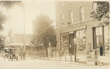
The clays of Ransom Creek that were once used to craft the pots and pipes of the natives were industrialized in the mid-1800s to make bricks. The Eshelman family used the quality clay, found along Ransom Creek, to build their homes and store in Clarence Center. The bricks were from the Eshelman brick yard next to Ransom Creek. They also built the large square corner storm at the corner of Goodrich and Clarence Center Road (Above). Most of the brick homes in Clarence Center were built with local clay from around Ransom Creek. There was a brick yard in Clarence Hollow as well. The clay is the remnants of the Tonawanda Lake bed.
The same escarpment that was used as a pathway and resource for making stone tools by the natives was also used to build houses and make gravel for road beds. Mining was another early industry in Clarence. Many gravel pits can be found littering the southern portion of the town. The most prominent one is Spaulding Lake, an old gravel pit that hit a natural spring and filled up with water in a day. The Onondaga Escarpment provided hard limestone. Farmers used the limestone to make kilns to cook the limestone down to makelime to be used for many different things on the farm. Remnants of a few lime kilns can still be seen throughout the region.
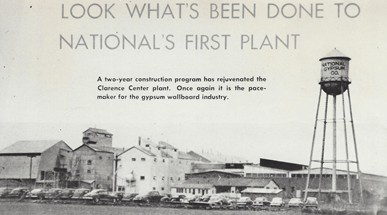
After farming, one of the largest employers in town was the National Gypsum mines (1926-1982) on Roll Road, just west of Clarence Center. The gypsum was determined to be the purest in the eastern United States. Gypsum is a naturally occurring soft mineral that is used for a variety of building material purposes, mainly for making gypsum board, or today referred to as drywall. The National Gypsum Mine in Clarence Center was one of the largest manufacturers of building materials in the country and advanced different technologies to make the boards (Right). The mine closed in 1982 because most of the gypsum was removed.
With one big industry closing, another filled the void. Wilson Greatbatch started Greatbatch Inc. in 1982 and is located on Wehrle Drive and has been a large employer with over two hundred workers today. Many other small businesses reside in the town as well.
Wars
Many of the early settlers in town were Revolutionary War Veterans. Men like Samuel Gallop and Asa Harris or Ephraim Derrick and Abraham Carmer fought in the War for Independence before settling in town. Most of these men came from Massachusetts, New Jersey, New Hampshire and Connecticut, with several from Pennsylvania as well. They fought in some of the most famous battles. Jonathan Blount fought in the Battle of Bunker Hill at the beginning of the war and at Yorktown at the end of the war. John Felton fought in the Battle of Saratoga in 1777, the turning point in the war. More than fifteen Revolutionary war veterans are buried in or around town. Many were buried in Harris Hill, Fillmore, Shope and Clarence Center cemeteries.
The War of 1812 was an international war with important battles fought in the town's back yard. December 30th, 1813 the town of Buffalo was burned. Clarence became a safe haven for the women and children fleeing Buffalo, while many of the townsmen were fighting and defending their community in the local militia, our very own minute-men. Some didn’t make it home, men like Sutherland Gallop, buried in the Shope Cemetery.
Many other town residents fought for our country in the Civil War, Spanish American War, World War I, II, Korean War, Vietnam and Iraq.
Schools
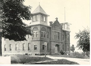
The first school was established in 1805 in Clarence Hollow near Ransom Road. The first teacher was Rebecka Hamlin. As settlers began settling in other areas of town, more schools opened up. By 1817 there were thirteen school districts with 512 students attending. It should be noted that Clarence still included the towns of Lancaster, Alden and Newstead. After the Civil War the town voted to combine several schools into the Union Free School, replacing the Clarence Academy. The Union Free school was the first of its kind in New York State. Eventually turning into Parker School (Right).
Several of the one-room school houses have been knocked down over the years, and some still standing have been turned into residential homes. For example, School District #6 still stands on the east side of Old Goodrich, north of Greiner Road and is almost unrecognizable with additions and modifications to turn it into a home.
By Joe McGreevy ©
Clarence Town Historian
Links
Clarence Preservation Commission
References:
(1983) History of the Town of Clarence, Oneta Baker
(1965) Archaeology of New York State, William Ritchie
(1876) Centennial History of Erie County, Cristfield Johnson
(1852) The League of the Iroquois, Lewis Henry Morgan
Other pictures Courtesy of Clarence Historical Society